Component C6: South-east area - Alaior (Calescoves, Torralba d’en Salort, So na Caçana, Rafal Rubí)
 Description, location and setting
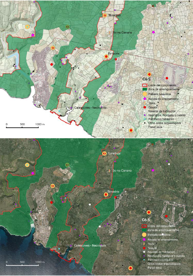
This component unfolds from the mouth of the ravines that converge on Calescoves (Biniedrís and Son Domingo), climbs up the Biniedrís ravine and reaches the smooth limestone plain of the south-east of the Migjorn, crossing two, clearly distinct landscape units. The area closest to the coast forms part of the landscape unit known as “ravines and platforms of eastern Migjorn”, while the area towards the interior of the island is included in the unit known as “plains of the Migjorn from Alaior to Maó”. The entire component part falls within the municipality of Alaior.
From the coast to the intermediate part of the area, around the village of So na Caçana, the vegetation is characterised by relatively dense wild olive forests. Next to the cliffs at the mouths of the ravines, the area presents a decidedly natural landscape in the crags, with little human alteration, bearing witness to its prehistoric vocation as funeral territory. From here, on the limestone plain, there is an excellent example of the unique Menorcan agroecosystem, with its combination of wild olive maquis, farmlands and grazing pastures enclosed in a grid of dry stone walls. This is the best-preserved example of the rural landscape of the south-east Migjorn, which also encompasses a large number of monuments and vestiges of prehistoric settlements.
As a whole, it is a very dense area in archaeological terms. 57 sites have been registered in this area of 502 ha, bearing in mind, furthermore, that some of these sites have multiple and diverse associated architectural remains around them. These include four Talayotic villages and the remains of another five smaller settlements. The settlement pattern indicates a distributed settlement, characteristic of the Eastern Migjorn plains, where there is no main population centre. It also contains nine talayots, including Torralba d’en Salort and Cotaina d’en Carreras that are laid out as nodes of the local intervisibility network.
The village of Torralba d’en Salort is one of the best-known in Menorca and, apart from the best-preserved and most spectacular taula site on the island, it also boasts two circular talayots, a hypostyle hall, a unique circular cabin from the Naviform period and an ensemble of artificial burial caves some distance away. The orientation of the taula, which was used until well into the 2nd century BC, is also exceptional, as it is one of only two cases in which these outstanding monuments of Menorca do not face south. This taula faces Sirius, the brightest star in the sky, but even so, it remains in a context of coherent relationships with all the other taulas. One striking fact is that this is one of the few places where, in a small area, there are three kinds of cyclopean construction, each representative of a different period: Naviform, Talayotic and Late Talayotic.
The So Na Caçana site, some 3 km to the south of Torralba d’en Salort, is an exceptional settlement, as it is the only one known with more than one taula enclosure (Fig. 2.a.vii.20). The site also boasts two highly unorthodox talayots, leading us to the conclusion that it is well-worthy of the consideration of a sanctuary. But it is still a village, because it contains circular houses from the Late Talayotic period. Like many prehistoric settlements of the island, it was used until after Roman times, as can be seen from the fact that it also has a small Islamic cemetery.
Close by So Na Caçana is the settlement of Torrellisar, which contains two talayots and a taula enclosure with an access that consists of a roofed corridor, built with historical dry stone walls (Fig. 2.a.vii.21). This settlement is sited in an important visual place and, as a whole, offers an interesting example of symbiosis between prehistoric cyclopean architecture and the dry stone walling works that characterise the traditional rural landscape.
The area of this component of the property contains outstanding works associated with prehistoric water engineering. These include the Na Patarrà well, set about 150 m from the village of Torralba d’en Salort, a spectacular structure and unique in the context of Mediterranean islands. Its ingenious design harnesses the natural joints in the rock, were they carved steps into the walls, forming up to nine flights of complex helical staircases.
The funeral places of this component clearly illustrate the unique traits that characterised the duality of the world of the living and the world of the dead of this culture, along with the reiterated territorial patterns. In the world of the dead, two exceptional features stand out: the spectacular funeral landscape of Calescoves and the Rafal Rubí burial navetas.
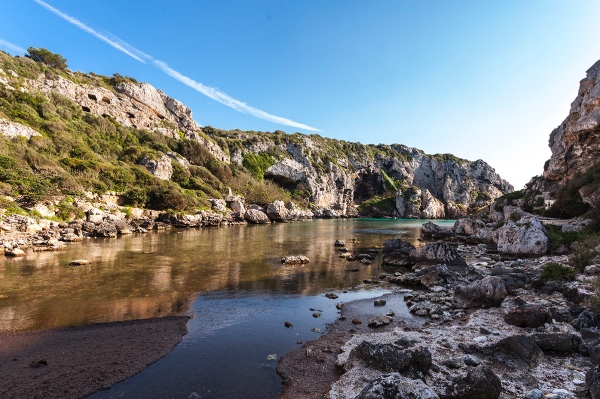
At the mouth of the Biniedrís and Son Domingo ravines is the rocky necropolis known as Calescoves, an area of exceptional landscape value that hosts a unique burial site of artificial caves in the limestone cliffs (Fig. 2.a.vii.22). This is the most extensive burial site on the island, where over 90 burial caves of very different kinds have been identified, ranging from the Naviform period, right the way up to the Late Talayotic. The Calescoves ensemble was the stage for the funeral rituals of the prehistoric communities of Menorca for almost 1,500 years, and excavations have provided many material remains, including religious artefacts and grave goods, overwhelming evidence of the universe of funeral beliefs and rituals of these prehistoric communities over the different periods. In archaeoastronomical terms, we are struck by the unique nature of the cave sanctuary of Calescoves, known as La Cova dels Jurats. Its orientation is similar to that of the taulas. But Calescoves is more than just a necropolis, there is also a fortified coastal stronghold to be found in this area, one of the few examples of settlement on the coast in this nominated property, and the underwater relics of when it was an important anchorage, as well as a small sanctuary from Roman times.
The underwater archaeological heritage is also noteworthy in this area. The boundaries of the component part include the marine area around the Calescoves anchorage. There are some important wrecks located in this marine area that hold significant material evidence illustrating trade and other relations maintained by the ancient settlers with the outside world.
There is a good representation of burial navetas in the component. The Rafal Rubí burial navetas, in the north-east corner of the component, are in strikingly good shape, and they clearly show the preference for locating these buildings in flat, concave spots, with a restricted view, such as Es Tudons. The topographic and geomorphological study of the area around the two navetas highlights their location on a slightly concave plain of modest dimensions, as the result of the surface erosion of Migjorn limestone – known in karstic geomorphology as polje – rimmed by a small limestone escarpment. This layout is very similar to the area around the Es Tudons naveta. The building of these unique tombs dates back to the Naviform period (1400 BC), and the case of Rafal Rubí represents an exceptional funeral site that includes two monumental burial navetas in a rural-natural landscape highly characteristic of the Menorcan Migjorn. Apart from these structures, there are also other chambers such as those to be found at Cotaina and Torrellisar, in this case, with a circular floor plan. Another striking aspect in the context of this component is the presence of the Biniedrís caves, the remains of which have provided evidence of the unique funeral rituals like “combing the dead”, which included dyeing the hair. This ritual has also been reported at other important sites like Cova des Carritx, where it was first identified.
 Main attributes: Monuments, sites and associated landscapes
- Torralba d’en Salort. This prehistoric village holds the privilege of hosting the best-conserved taula enclosure in Menorca, which is even more outstanding for two reasons. In archaeoastronomical terms, it represents the exception to the rule in the orientation pattern of these monuments; and in chronological terms, it is unique in that it was used for up to two centuries after the decline of the Talayotic culture of Menorca. Furthermore, it is an exceptional case in that one can find cyclopean architecture representative of all the different periods, all together, including outstanding works associated with the water culture (Criteria (iii) and (iv)).
- Rafal Rubí. This is one of the few places on the island that can boast two burial navetas, outstanding monuments unique to Menorca, and illustrates the territorial duality between funeral and living territories that characterises the expressions of this culture (Criterion (iv)).
- So Na Caçana. This is the only known example of a settlement with two taula enclosures and, according to the evidence, it is an exceptional case of a religious settlement (Criterion (iv)).
- Calescoves. The Calescoves necropolis is the most extensive burial site on the Island. The many burial caves scattered around the cove and towards the interior of the ravines that comprise it include a wide diversity of different kinds, illustrating the different stages encompassed by all the periods of the island’s prehistory (Criterion (iv)). The many material finds provide a unique window onto the funeral rituals of the prehistoric communities from the Naviform until the Late Talayotic period (Criterion (iii)).
- Associated landscape. This is the component that best represents the original relationships between the world of the living and the world of the dead in prehistoric times. These traits are still tangible in this component today (Criterion (iii)). The southern half turns into a funeral landscape, hidden inside the ravines and the cliffs at their mouths, practically unchanged since prehistoric times, while in the northern half, we see the emergence of an area representing the Menorcan agroecosystem, which illustrates a singular process of resilience of the prehistoric cyclopean landscape (Criterion (iv)).
- Intangible attributes. This component is highly representative of the power that has emanated from the cyclopean works of the ancestors to inspire myths and legends that have formed part of Menorcan intangible culture. A good example of this is the legend of the five giants that used to meet around the taula of Torralba d’en Salort, or the myth that considered the Na Patarrà well as one of the gateways to hell (Criterion (iii)).
Protection of the component and uses of the land
75% of the listed archaeological remains in this component have been declared Heritage of Cultural Interest (BIC), including all of those mentioned in the description. The natural and landscape values of the lower part of the space, down to the coast, have been given protection within the framework of the PTIMe as ANEI (Nature Areas of Special Interest) and ANIT (Nature Areas of Interest). The rest of the area, of great traditional farming value and important landscape interest, is zoned as an AIA (Area of Agrarian Interest), except for the ribbon around the Cotaina necropolis, also considered an ANIT. The southern part, covering much of the funeral places, is included in the Natura 2000 Network. Furthermore, the review of the PTIMe (2020) reinforces the safeguarding of the component by zoning it as an Area of Landscape Interest (AIP). These land use measures guarantee the protection of the area and are fully consistent with preserving the prehistoric and landscape heritage of this component.